
Start: Just before you reach the Kirk, the last house on the left has a gateway that leads onto a path down through the woods. Follow this path down with the golf course to your left. As you come close to the houses of Archerfield Village the path turns right though a couple of bends to continue at a right angle to your woodland path. This path continues with houses to your left behind a wire fence and a ditch and fields to your right. You can EITHER take this path right along to Yellowcraig car park and walk back up the narrow road from the car park to the east end of Dirleton Village* and then turn right onto the main road through the village to the Kirk, which is on the right off the far end of the village green. OR about half way along the the path you will see a slightly raised track on your right between fields. If you follow this it will take you back to the Kirk by a shorter route.
*Yet another variation is to look for the green John Muir Way sign about half way back up the road from Yellowcraig car park to the village and turn right past Radar House and left though farmyard buildings and then right ahead to join the signposted pathway back into the village.
Approx time taken at steady pace: Half to one hour. Can be muddy and slippery, particularly on the first section in winter.
Please keep your dog on a lead, as there are deer in this area. Regular dog poo boxes along the route.
In Dirleton village, if you walk down the street from the Castle Inn towards the Kirk, you will see a lodge house beside the entrance to the Archerfield Estate on your left. This is a tarmac track which goes straight along into the Estate, with fields and trees on your left and a golf course on your right. Keep on this track until it comes to a junction with the main private road from the A198 into the estate, turn left and then right along another section of straight road which shortly brings you to the entrance to the Walled garden on your right. Here there is a cafe/restaurant for snacks or meals with a child’s play area.
Retrace your steps to Dirleton.
Approx time at a steady pace: about a half hour walk each way.
Distance 6 miles. Time 3½ hours
This coastal walk explores the coast and dunes east of Gullane. It passes the world famous Muirfield Golf Course which has been host to the Open Championship on many occasions, the latest being held there in 2014.
From the Gullane Bents car park head east on a broad rubble road. Beyond a small wood the path narrows and becomes a sandy path through an area of buckthorn. Keep right at a junction and after crossing a small footbridge follow the path beside the golf course. When the path comes into more open ground there are good views of the course and the impressive club house. The track continues towards a large wood. There is a diversion through the edge of the wood to bypass a large green building. There may be further diversions connected with proposed tree felling operations in the area. Any diversions should be clearly marked. Either follow the broad track as it bears left towards the shore, or straight ahead along an apparent cart track towards the dunes. Much depends on the state of the tide. If the tide is well out then the sandy bays and rocky outcrops make for a fine walk. Equally, if the tide is high, then the many paths through the dunes will enable good progress to be made eastwards.
After passing the house known as Marine Villa the island of Fidra is seen offshore. It is believed that this was the inspiration for Robert Louis Stevenson’s ‘Treasure Island’. The author spent holidays in North Berwick and it is said that he wrote most of that work there. Opposite Fidra turn right and walk inland towards Yellowcraig carpark. At a gate turn right and follow the route of the John Muir Way. Continue along the well used path through a woodland strip, with a high security fence on the right. The path eventually leaves the wood and heads towards Dirleton on a broad field track. The route arrives in Dirleton near to the church and village green.
The main route back to Gullane is through Archerfield Estate, following the signposted John Muir Way between the East Lodge in Dirleton and the West Lodge on the outskirts of Gullane. Alternative options include walking along the roadside footpaths to Gullane, or take the bus service 124 and X24. FirstBus Website is at https://www.firstbus.co.uk/
If time allows do visit Dirleton Castle. Built by the Norman family of de Vaux in the 13th century, the ruined castle dominates the large village green. There are two hotels in the village and a tea room in the gallery near to the church.
Please note: All distances are approximate. Times depend on time spent taking photographs or eating your picnic lunch, etc.
Compiled by Peter Jackson for Gullane Area Community Council
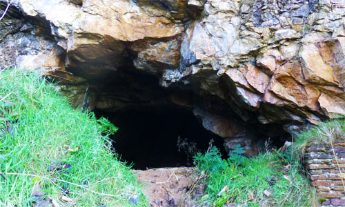
Hanging Rocks Cave (Photo by Fred McClintock)
(Takes approx. 2 hours)
From the East Lodge on Dirleton village green walk west along the John Muir Way JMW) with Archerfield golf course to your right. Turn left and then right (off the JMW) and walk past the entrance to Archerfield Walled Garden where a wrought iron gate straddles the road. There is a path to the left of the gate. Pass the houses on the right. Just as the road turns to the left there is a gate and a path on the right. Take this path. Walk on and you will pass a small group of new houses on your right. Continue to walk on along the path and you will see the Renaissance golf club house on your right. Where this path ends, turn right onto the golf course path on your right. After a short stretch, bear left and follow the path through the golf course, passing a group of sea buckthorn on your left, laden with orange berries. Continue on for a bit and then cross the rough grass on your left and go down onto the shore. Turn right along the shore and after a short stretch you will come to a stone cliff formation bordering the shore. If you clamber up the sandy bank and you will find the first of the cave entrances, set into the cliff face. The second cave can’t be seen from the shore, but if you climb up the bank, it is around to the left of the first cave.
To return to Dirleton village follow the coastline east as far as Yellowcraig beach, head inland to the car park and public toilet/showers and from there south along the John Muir Way.
Apparently the “old man of Dirleton” used to live in one of these caves. A detailed location plan and historical information can be found on the Canmore website. The location is also identified as “Fortress of Solitude” on Google maps.
walk courtesy of Fred McClintock
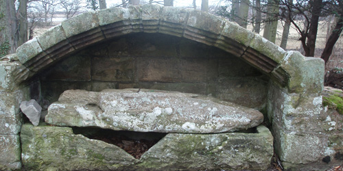
Medieval Knight – Bickertons Way
This is a lovely Spring walk with a profusion of wild flowers, but also fascinating at any time of year for its mysterious sense of history. It takes about an hour depending on your options and sections can be muddy.
The start is quite close to Aberlady. From Dirleton drive through Gullane and at the point where the road bends round towards Aberlady Bay by the Luffness Golf Course, take the straight road turning up towards Luffness Mains Farm. This road curves round into a long straight section. About two thirds of the way along there is a belt of trees on the left just before the last large field. Park on the verge here where you will see on the right a signpost for the walk with a sign for Bickertons Way and the Postmans Walk.
Follow the straight woodland footpath. On your left are the woods of Bickerton Strip carpeted in snowdrops and aconites in early Spring and on the right a field with an old water tower for Luffness House. The path comes to a signposted fork and there are various options. Left on Postmans Walk takes you to the ruins of a Carmelite Friary dating from at least the early fourteenth century and the remains of two fishponds which would have served the friary. There is a mysterious archway covering the weathered form of a nameless knight, laid out in his armour. You can follow this path round in a loop onto the road and back past the cottages of Aberlady Mains to your car. Or you can double back from the friary, taking the right turn at the signpost towards Luffness House, again with wood on your left and the field on your right. This wood has primroses in the Spring. This path peters out near Luffness House which is private, so you can either double back to your car along the paths you have taken, or follow the edge of the field on your right in a semi-circle back to your car. The Water Tower in the field acts as a guide. The field edge comes out onto the road shortly before where you will have parked your car.
Further information can be found at https://mysearchformagic.wordpress.com/2013/02/10/luffness-friary-aberlady/
Time: One and a half to two hours. Distance 3 miles.
START:
Leave the A1 at the Thistly Cross roundabout south of Dunbar and take the B6370 for 3 miles to Stenton. Go left at the end of the village (in front of the primary school) and after almost a mile down a narrow lane, go left again following the sign for Pressmennan Wood to reach the car park.
At the end of the car park, there are two gates, take the one on the right, leading through trees on the side of Gallows Law. Before the top of the hill, the track goes into a clearing with good views and on the other side the path continues up. You then begin to drop down – ignore the path on the left. The path goes right, then swings round and down to the left to reach a track, where you go left. After a few hundred yards go right at a wooden carving, down a path which runs above Pressmennan Lake. Pass a bench, then wooden carvings that make a tree look like a house, before going through a tunnel of overhanging rhododendrons. The path eventually reaches a track at the end of the lake. Go left, then left again almost immediately (on the other side of a holly bush) to follow a path to the track below the car park. Turn left to return to the start.
There is a much shorter children’s trail of magic sculptures reached just below the car park and turning off this track to the right at a yellow stone.
Based on a walk in The Scotsman, Spring Walks for a great day out 2010
Smeaton Nursery, Preston Road, East Linton EH40 3DT
Open daily from 10am until dusk. Can be muddy in winter or after rain.
A short and easy trail accessed from the driveway up to Smeaton Nursery Gardens in East Linton – on the left just after a cattle grid.
A leaflet detailing the beautiful collection of trees around this lake can be picked up at the nursery and is well worth obtaining first as it locates and names many of the unusual trees that were collected and planted by the two families that owned Smeaton House (now demolished) in the nineteenth and twentieth centuries.
This walk is one of a number of sites participating in Scotland’s Tree Trails.
For more information see Smeaton Nursery Gardens website